Canada releases pictures of world's most northerly shipwreck
Breadalbane sank in 1853 on search for Franklin expedition
Wooden three-master is well preserved in icy waters
Share
Tweet this
Email
Suzanne Goldenberg, US environment correspondent
Follow @suzyjiFollow @guardianus
theguardian.com, Saturday 26 April 2014 09.38 EDT
Jump to comments (
)
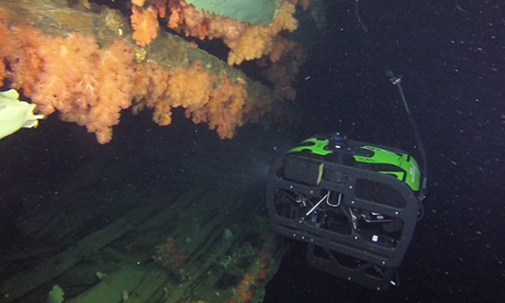
Breadalbane The barnacle-encrusted hull of the supply ship Breadalbane is revealed in waters off Beechey Island. Photograph: Operation Nunalavit/Flickr
Canada has released underwater images of the world's most northernly shipwreck a three-masted merchant ship that went down 161 years ago after becoming trapped in Arctic ice.
The Canadian Armed Forces and Parks Canada produced the footage over six days, lowering a remotely operated HD camera through a hole in the sea ice, to capture images of a barnacle-encrusted hull and anchor from the ocean floor.
It's rare to have such a detailed view of a shipwreck from 1853, Jonathan Moore, a senior underwater archaeologist for Parks Canada, said in a statement. We anticipate more discoveries and insights as we pore over the collected information.
The Breadalbane sank in the Barrow strait in August 1853, after becoming trapped in packed ice near Beechey Island in what is now Nunavut. The ship was a supply vessel for ships searching for traces of the doomed Franklin expedition.
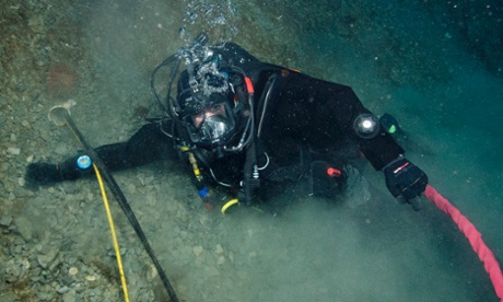
Breadalbane Leading Seaman Keith Slade checks the cables running from the DRDC camp to underwater sensors. Photograph: Operation Nunalavit/Flickr
Captain John Franklin was searching for a route through the Northwest passage when his ship also became icebound. The entire crew of 128 was lost.
The Breadalbane was the last and the largest of a series of ships sent out by the Royal Navy to discover Franklin's fate. It also got trapped in fast-moving Arctic ice, and sank within 15 minutes.
The 21 crew abandoned ship; all were eventually rescued. The Breadalbane remained undiscovered in 100 metres of water until 1980.
It has since been declared a national historic site in Canada.
http://www.theguardian.com/world/2014/apr/26/canada-shipwreck-breadalbane